The Hunters Lap of Australia
"Gone Bush"
Devils, Bustards …and thermal pools
We turned right onto Highway 87 out of Alice Springs a little before midday and headed northward for the Karlu Karlu / Devils Marbles Conservation Reserve (20°33′S 134°17′E) 120kms south of Tennant Creek.
We had previously stopped by the Marbles on September 24, 2015 for a brief hour or so on our way to camp at the Kunjarra / The Pebbles site 18kms north of Tennant Creek and onwards up to the Kimberly. This time around, we wanted to camp out at the Devils Marbles campground and to hopefully capture a nice image or two of a sunset across this small but remarkably beautiful and unique reserve.

The granite marbles are everywhere around the reserve, this one nicely positioned next to a lovely ghost gum. Copyright Geoff Hunter
Karlu Karlu is the local Aboriginal name for the granite rock features. The anglicised Devils Marbles name derived from Scottish explorer John Ross who, on route to Darwin, wrote in his journal in 1870 describing the area as “devil’s country” where the devil emptied his bag of marbles all around the place. And you can easily view it like this, it does look something like a scene out of a dark children’s tale or fable.
We pull into the Marbles campground at 4:30pm, 37Deg, and greeted by LOTS of friendly flies. We immediately notice a couple of bushfires that had gone through various parts of the campground and throughout a large area of spinifex and other heath within the Marbles themselves. A crying shame really …the time it will take to repair will likely take many years (if at all) and the larger fire next to the campground looked like it was started from a campfire and had taken place since we were last here and during the “total fire ban season”. No wonder we see signs all the time with the moniker; We prefer our lizards frilled, not grilled”

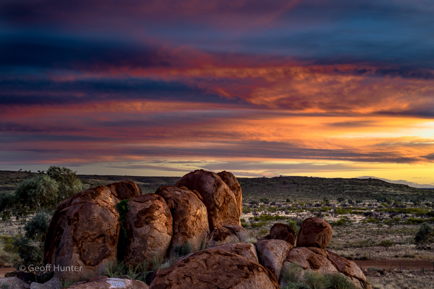
Last light at Karlu Karlu / Devils Marbles, Northern Territory. Copyright Geoff Hunter
On the drive up to the Marbles, we were observing lightly scattered arrays of Altocumulus cloud formations. We were occasionally watching them over the course of the afternoon to see if they were going to stay in a lenticular formation until sunset (which would be ideal), evaporate or, as they often do, slowly merge together usually just above the horizon to create a large thick cloud band as sunset looms. They did the latter …thankfully not to the extent they usually do and we had a reasonable wide cloud coverage that was not too thick in some places allowing lovely sunset colours to penetrate the cloud and others to reflect.
After camp setup, we head up into the granite boulders looking for suitable angles and interesting granite shapes to shoot about 45 mins or so before sunset. Some of the better spots were amongst the bushfire areas that were now blackened and charred and looking anything but photogenic. We eventually found a decent position on the southern section of the Marbles looking almost directly south across the entry road to the campsite within the reserve. The cloud formations and colours were doing more interesting things towards this direction than west, directly at the sun. We rattled off a few frames whilst the boys had a great time trying to catch many of the large multi-coloured flying grass hoppers that also call the marbles home. It was not the best sunset I’ve seen, however given the unique location, the desert surrounds with the balanced granite boulders all around with a sunset backdrop, made it special and the colours and hues were not too bad in the end as well.

An after sunset silhouette taken from our campsite at the Devils Marbles, Northern Territory – April 2016. Copyright Geoff Hunter
When we got back to camp it was almost dark by this stage and Celia sees a lovely ghost gum silhouette looking back towards the marbles from our van and asks if there is enough light to shoot it. I glance back at where she was referring to and say, ‘Sure’. Plonk the tripod down and a 35sec long exposure later, we take was to be the final image for the night (which is the one left) and prepare for dinner. After a warm and somewhat restless night, the following day …let’s just say, it stated out quite eventful.
It was going to be a long day’s travel as our plan was to get up to Mataranka at a distance of 672kms and stay at the Mataranka Homestead to have a relaxing swim in the thermal pools before dinner. After brekky we depart the Devils at 8am, another lovely still day and it was noticeably warm early on. It’s going to be another hot one with a forecast of 38Deg – a good day for travelling in an air-conditioned vehicle.
Heading further north and approx. 40kms south of Tennant Creek, we come across a group of 6 or 7 Brahman Cattle standing in the middle of the highway. We quickly slowed down and as we carefully approached, a couple of them (the young males presumably) showed an obvious displeased bravado towards us (one of them in particular bucking and kicking in a slightly humorous and awkward adolescent way) as they reluctantly moved their carcasses off the Hwy and onto the shoulder and all stared at us as we slowly and safely passed them. Oddly though, with the amount of road trains in this part of the NT, it is most unusual (at least to our observation) to see as many cattle as this on the highway at this time of the morning.

Creative Commons – Wikipedia. This Australian Bustard was a similar size to the one that we hit 30kms south of Tennant Creek. April 2016
Several minutes later, we see two strange largish looking creatures in the distance, one appeared standing still, the other slowly ambling off the left-hand side of the highway. I immediately hit the cruise-control cancel button and coast a few seconds and initially we thought they may have been a pair of Brolga’s, but soon realise they were a pair of large adult Bustards.
As we get closer, one of them stops and freezes in the middle of our lane and peers directly back at us. I knew we would not be able to pull up in time if it stayed put so I veer the D4 across onto the oncoming lane (don’t worry, it was a very long straight flat stretch of road and we could see a km or two ahead) in the hope it would move off after its partner. As I did this, the frozen ‘Baustard’ decides to switch direction also and heads to our side of the Hwy and tries to take flight and does so straight into our windscreen in-line with Celia’s head with a huge bone-crashing thud. Celia lets out a little inpromptu scream, both boys grunt out a “ohhhhh”, and as I glance back in our side mirrors, I’m relieved to see he/she had miraculously flown off – no lost feathers, nothing showing I could see of the coming together except for a few tell-tale signs left on the windscreen itself. (Before noticing the birds, the cruise-control was set to 98Kms and at the time of impact, we would have been closer to 5o-55kms. The impact from the Bustard was very loud and we’d hate to imagine how the end result would have been if the large bird hit the middle of the windscreen. Thankfully, he/she did not and looked to have flown off to live another day, albeit with a new bruise or two).
We soon pass through a quiet Tennant Creek just after 9am – most shops still looked shut except for the bakery, schools, service stations and KFC. Just north of Tennant Creek and before the 3 Ways intersection for Queensland, Celia and I were just discussing our diesel situation and thought we would refuel at the 3-Ways roadhouse rather than another 130kms further on. A minute later a 4-trailer mining road-train hammers past us and throws up a rock and hits our windscreen on the bottom right hand corner with a huge bang leaving a deep stone chip, but amazingly, no crack …yet. As they say, things happen in 3s. Ten minutes later, we pull into the 3-Ways roadhouse to refuel and inspect the hit from the Bustard and rock – a couple of superficial marks – all good, however eventful.

Looks like a suburban swimming pool, right? It does, but this is a naturally fed thermal pool at the Mataranka Homestead where the mineralised water comes up out of the ground about 90M to the right of image.
The rest of the day was kind of boring by comparison and we all had a nice drive from the 3-Ways up to Mataranka listening once again to Dr Karl Science podcasts and pulled into the Mataranka Homestead at 4pm. We quickly setup (20 mins) and headed down to the thermal pools for a nice long soak. The thermal pools here are about 34deg all year around and are a little on the nose with the ever-present smell of sulphur. You soon get used to it and the pools are lovely and clear and just what we needed after a long days driving. That night we have dinner at the homestead restaurant – the boys had their usual fish and chips and afterwards, had fun chasing cane toads around the place.

Bitter Springs Aquifer in Mataranka, NT. You enter the water in this natural spring pool, either swim or drift downstream in the slow current to another pool just like it to exit, walk back & repeat. It’s hard work but somebody has to do it!
The following day we try to confirm road closure/conditions to Mataranka falls. As it turned out, the road was still closed (apparent croc threat) and we could not access the falls – so off we went to Bitter Springs thermal pools for a couple of hours. These are warm waters (not quite as warm as Mataranka Homesteads Thermal Pool) from an aquifer that flows into the little Roper River. You access a head pool of the Spring and drift with the gentle current down along the winding spring that connects the two swimming pools and exit on a ladder at a pedestrian bridge at the other end. We all did this for an hour or two with numerous others (some were using noodles which seemed like a good idea) and the boys loved exploring and looking for turtles that live in this crystal clear and very warm water. We find a nice shaded area in the picnic ground adjacent to the springs car park and have a sandwich before heading off to look around the “open sections” of the Elsey National Park are some parts were still closed from the wet season. There was not so much to see, little bird-life during the middle of the day’s heat and soon enough end up back at camp and then headed back down the Mataranka thermal pool as the warm water of the spring is cooler than the ambient temp.

Crossing the Katherine River which is running low for this time of year. The wet season was not as wet as usually is and the town has water restrictions already in place. Bizarre for a place and region that typically gets so much annual rainfall each year, but not this season. Copyright Geoff Hunter
The next day we pack up early and make the short trip up to Katherine (a.k.a. birthplace of Cadel Evans we noticed) and here is where we hope to plan the route options for the leg of our journey across the Savannah Way and parts of the gulf region to Karumba, but not before we make a visit to Nitmiluk and Litchfield National Parks in the coming few days.
‘Til then…
Geoff & Celia

Leave a comment