The Hunters Lap of Australia
"Gone Bush"
Chambers Pillar
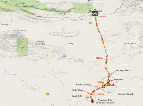
Chambers Pillar return trip by SPOT with a few useful overlays. Copyright Geoff Hunter
We’ve now arrived back in Alice Springs for the 2nd time on this trip. Even though this time, (unlike the first), is unplanned, its still nice to be back here as there is always something to see and do in the Alice. However in doing so, we somehow forgot a pretty important time of the year, completely – the Easter long weekend.
Not only do we have Easter crowds to contend with we have also run into another late season hot spell with temps in the high 30s. After forced to change our route from Birdsville to Alice Springs due to rain and road closures, we only wanted to spend a couple of days in Alice before heading out to the West MacDonnell Ranges for a few nights. At Easter time, the West Macs are a favoured holiday location for the Alice locals and finding a campsite in the national park will be difficult. We therefore decide to stay in the Big4 holiday park out at the Gap in Alice until Easter Monday, then head out to the West Macs Redbank Gorge area hopefully at a time when holiday makers are packing up to leave for home?
Until such time, we keep ourselves busily entertained by doing day trips – particularly where 4WD is required in the attempt of missing most of the Easter crowds and Chambers Pillar, 161Kms south of Alice, seemed like the obvious location for us.
History of Chambers Pillar
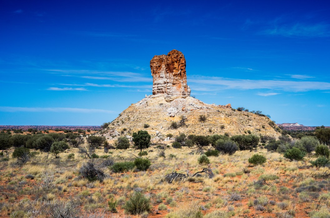
 The main feature of the Chambers Pillar Historical Reserve is a sandstone pillar that stands 50M above the surrounding plain on one side and the edge of the Simpson Desert on the other.
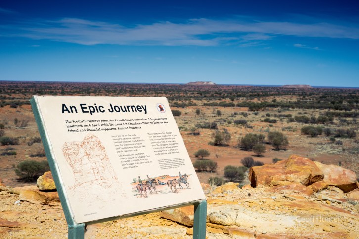
And its not so much the physical landmark of the pillar itself that has the historical significance, but rather, the column is a key reference point and originally marked the first successful overland journey from Adelaide to Alice Springs by John MacDouall Stuart back in 1860. He subsequently named the pillar after James Chambers, the sponsor of Stuart’s expedition at the time.
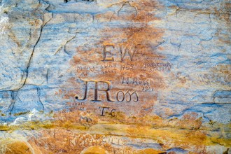
John Ross @C1920
Over the many years afterwards, the pillar became a major desert landmark up until the 1920s for all subsequent journeymen, and during this period, helped pave the way for the Ghan railway and Overland Telegraph Line. It was John Ross, the leader of an exploration party that lead the Overland Telegraph Line construction at that time, and Alfred Giles, his 2IC, both of whom have their names engraved at the base of the pillar, making these men genuine pioneers along side of Stuart.
Unfortunately, since the old and wonderful pioneering days, in more recent times, a number of visitors to the Pillar have felt the need to inscribe their names (as very recent at 2016 we noticed) directly next to the early explorers names for reasons that are simply beyond my realm of thought. (We read the NT Government have tried to find and prosecute people who do this without much success, sadly).
Historical information out next to the pillar about the early explorers that came through this desert region. Simpson Desert in the background.
Access and rudimentary trip notes
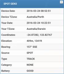
Our SPOT coordinates at Chambers Pillar
DISCLAIMER: The primary intent of this post is to document our journey out and back to Chambers Pillar for the benefit of our blog followers and as a trip account for ourselves. Invariably, some people reading this post, such as “blog visitors” for example from a search engine query, may choose to repurpose our trip notes as a reference for there own journey out to the Pillar, whether this is a sound approach or not.
As such, we have decided to expand the normal level of detail of our trip notes and provide our own GPS coordinates, Distance markers based on our GPS device, HEMA maps we used and Land Rover Discovery Odometer readings. ALL OF THESE or PART THEREOF MAYBE DIFFERENT TO YOUR OWN READINGS IF USING THESE, with the exception of GPS coordinates. Therefore if you decide to use any or all this information to plan your own trip to the Pillar from Alice, please factor in room for error and any anomalies that ‘may’ result between your equipment and the equipment we used. Most importantly, be prepared, do your homework and be safe.
Introduction
Chambers Pillar Historical Reserve rates fairly highly among 4×4 enthusiasts that we could tell from speaking with locals, presumably because it has a bit of everything and takes the best part of a full day in rather remote desert country. It is also a favoured trip for those wishing to get a small taste of what the Simpson Desert is like.
The route consists of, Soft Sand drifts, San Dune crossings, Creek/River crossings (usually dry), Rocky outcrops, Bull Dust and long straight corrugated roads through wonderful desert scenery. Route finding is fairy straightforward for the most part, however a wrong turn can be taken easily enough. Ensure you take plenty of drinking water too – there is none out there, and more than enough fuel to get back home safely and enjoy.
Trip Notes & Logs
From the centre of Alice Springs to Chambers Pillar return, is 322kms, 295kms unsealed. (Note; Our kilometre reading(s) also take in the Rodinga Ruins and a trip into and out of the township, Titjkala). If using HEMA maps for example, their numbers will be slightly different as they don’t take the two off main road excursions we did so bare this in mind.
First off, head south out of Alice Springs along the Stuart Highway for 11kms until you reach the Adelaide T-junction. Continue straight ahead at the Adelaide (Coober Pedy et al) turnoff and the road at this point becomes Santa Teresa Road. Approx. 400 metres passed the Adelaide T-Junction, is a small road on the right, Maryvale Rd, or on some older maps maybe marked as “Old South Road” however the sign post is marked Maryvale Rd. Take this right turn and this is where the road immediately turns to gravel and the start of the Chambers Pillar route from Alice.
In our case, we hit the Maryvale Rd start just after sunrise and immediately pull over to adjust our tyre pressures. From the start of the Maryvale Road/Old South Road, follow the road for 106kms till you come to a signpost marked “Rodinga Ruins“.
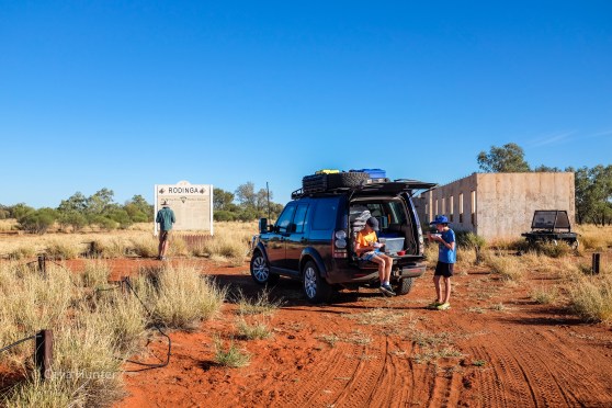
Having breakfast at the historic Rodinga Ruins Siding once used for the old Ghan railway. Copyright Celia Hunter
For the first 50kms or so from Santa Teresa Rd, the road was often populated with Santa Gertrudis Cattle. They were pretty level headed cattle for the most part and typically sought to get off the road quickly, but keep a watchful eye out for these large beasts early in the morning and watch your speed along these parts as its easy for your speed to creep up along the long straight sections. There are several turnoffs along this 1st section of the road mainly to Aboriginal communities and the odd homestead, and the road at the time was in reasonable condition although I don’t think it had been graded in quite a while.
After 106kms and a photo or two, we stop at the Rodinga Ruins -24.55457, 134.08643 which are approx. 300M off the main road on your left for breakfast. The night before, Celia made a Bircher Muesli and we had fresh berries with it bought the day before. (A little decadence in the desert). We take a look around the old Rodinga Railway Siding once used for the old Ghan Railway – there were no left-over signs of the old track here (at least not obvious) and the station buildings are now a mere shell of their former glory. It’s an interesting place and well worth the stop – even if to stretch the legs or take a little respite from the corrugations.
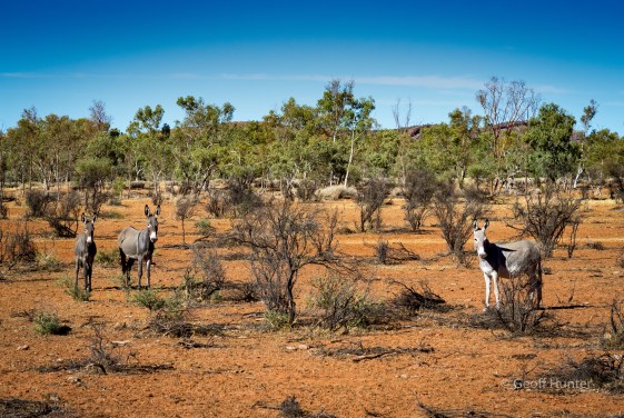
Aren’t they cool looking animals. These Donkeys look like they are in good condition and healthy looking, presumably wild. The one on the far left a foal?
We move on to Maryville Station a further 12kms down the road and by this time its 8:45am and 30deg. (NOTE: You can buy diesel at the Maryvale homestead if you need it, though we’d expect you’ll ‘pay’ for it out here?)
The road skirts by the Maryville Homestead and you’ll pass some cattle yards and some large machinery in a couple of paddocks as you first see come into view of the small Aboriginal community and township of Titjikala. (Note:The sign welcomes visitors to enter the township and respectfully look around without having to pre-arrange permission).
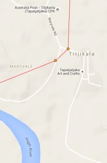
As per our SPOT GPS device.
It is at this point where you can easily miss the turnoff to Chambers Pillar, despite signposted. When approaching the township of Titjikala, you will come to a sweeping left hand bend before it descends down to a causeway across a dry creek bed. Just before reaching this bend, bear right slightly at the fork here – see image from our GPS device. The GPS coordinates at this point were – 24.67075, 134.07376 – take this red sandy track that skirts the right edge of town which becomes the start of the final run out to Chambers Pillar and where the fun begins. This leg is 45kms and should take a good hour (or more) and there are plenty of photo opportunities along the way.
In our case, only 2Kms from the fork the track weaves through a couple of narrow cuttings in sand dunes, we rounded a right hand bend and standing on the left side of the track were three grey Donkeys – presumably wild? We pull over and fire off a couple of photos and they were clearly wary of our presence and moved to what they thought was a safe distance from us – about 100M. (As a side note; This is the first time we had seen wild Donkeys on this trip in 23,000Kms).
A few kilometres further on, the narrow track will converge down to a two-wheel track to a 200M crossing of the Hugh River at GPS coordinates –24.68539, 134.03586. It was an interesting looking crossing *if* the river would be flowing, however very straightforward when dry as it was on our day.
Celia at the wheel of the D4 ascending Charlotte Range. Copyright Geoff Hunter
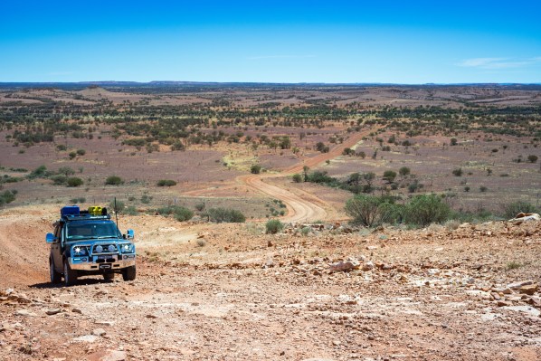
After the creek/river crossing, the road weaves in out of some low-lying sand dunes and some bull dust before you arrive at the base of a steep rocky pass over the Charlotte Range. There are good photo ops from its summit and you will see the first glimpse of the Simpson Desert from here. There is a moderately steep decent on the pillar side of the range where low range is probably best engaged.
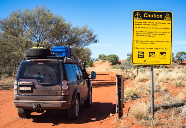
First gate and entrance to Chambers Pillar Historical Reserve. A couple of warnings to take note of but it’s not as serious as it reads …common sense really. Copyright Geoff Hunter
After crossing Charlotte Range, the road gradually narrows and the red sand again forms the main track surface – soft in some places, hard-packed in others but generally easy going. You will then come to the first of two closed gates and a caution sign of the sand dunes to be negotiated ahead before reaching the pillar. The first gate also signals the entry point into the Chambers Pillar Historical Reserve. Continue to follow the now narrower track up and over numerous sand dunes (care should be taken on the crests of each dune as there is only room for one vehicle at a time and most are blind) and soon enough you will get your first glimpses of the pillar. After the final couple of dunes, the road turns back to more gravel than sand and a small campground sign pointing to your right emerges – go here if camping or continue straight for another 200M to the turning circle under some large desert oaks and park here. You are at now at Chambers Pillar. (You will also notice some stainless steel gas BBQ’s next to a couple of picnic tables – they were clean when we were there and gas is also provided FOC).
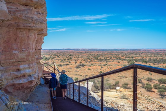
The boardwalk on the western side of the pillar. Here you can read all the past explorer scribes, but also unfortunately all the other vandalism and graffiti from other (insert appropriate adjective here)
Across from the carpark you will see an open hut (more like a bush Gazebo) with a lot of useful and interesting historical information about the Chambers Pillar site and a sign in book.
The walk out and back to the Pillar starts here and is approx. 45minutes return assuming you take the stepped hike up to the boardwalks and walk the base of the Pillar. By doing so you will get great distant views of the surrounding landscapes plus a good look at the Simpson Desert on one side of the Pillar. If history is your thing, be sure to take your time looking at the large pieces of sandstone around the bases where you might find early explorer engravings – some of these such as John Ross …and others are on the base of the pillar which can be seen from the boardwalk. (It’s just a shame there is so much vandalism in the form of other visitors scribing their names everywhere – but enough said in this)
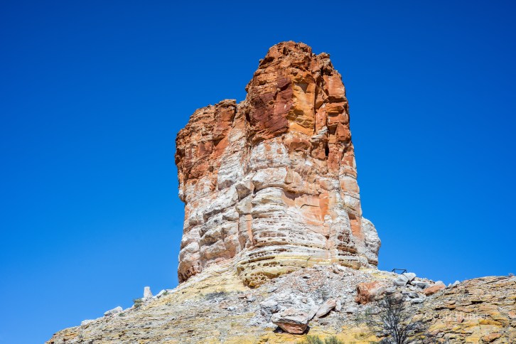
Chambers Pillar from below the base. For scale, you can just make out the boardwalk handrail to the right of the base of the Pillar. Copyright Geoff Hunter
We stayed just under 2hours out at the Pillar, had a sandwich before the temp reached 37deg, and soon enough started our journey back the same way we came in. On the way into the pillar we didn’t pass another vehicle all day and it wasn’t until we almost reached Titjikala on the way out before we saw the first vehicle of the day towing an off-road camper through the sand drifts on its way to the pillar. A cordial wave and they were gone…
41kms from Alice on the Maryvale/Old South Rd, appearing out of nowhere, you pass an interesting densely populated forest of desert oak seedlings growing just off the road. Unusual and striking looking trees when they are seedlings and such a wonderful contrast in a desert landscape.
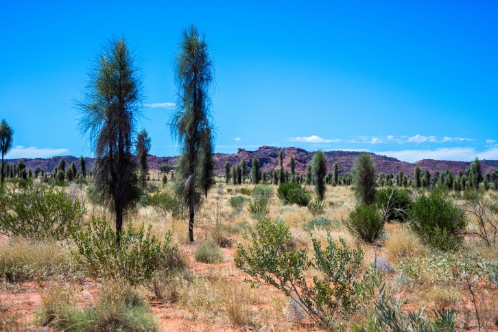
Young Desert Oaks or a plantation of Feather Dusters? Copyright Geoff Hunter
In Summary
It can be a long day, albeit a lovely desert trip and not too hard on your equipment if you take it easy, and 4WD with low-range in some sections is highly recommended.
There is always something interesting to see …and from a photography perspective, would be much better to see and photograph this lovely historical landmark at either sunset or sunrise when the atmosphere and colours will be at their richest – but is still good anytime.
If camping out at the pillar is your wont; there is no water so make sure you are self sufficient. The few camp spots looked flat, perhaps with sparing shade. *We* wouldn’t recommend caravans, even heavy off-road versions, however camper trailers should be fine.
As a final reminder; *If* planning on using our notes for your own planning purposes out to the Pillar, please feel free to do so …but use as one source in many researched approach. We researched many different sources, maps and headings before our trip and found varying distances and supporting information sometimes didn’t quite marry up, so beware.
If you have any questions or comments, please do drop us a note.
Geoff & Celia

For those who may use this information to plan there own trip out to Chambers Pillar, if you have any questions on the route or about conditions that we haven’t covered here, post your question below and we will endeavour to answer them.
LikeLike