The Hunters Lap of Australia
"Gone Bush"
The Pilliga and CSG
About 20 years ago, I read passages from a book called “A million wild acres”. It’s a non-fiction writing by a once farmer come ecologist, Eric Rolls, about the unique forests of the Pilliga which sit between Narrabri and Coonabarabran in New South Wales. His book touches on the ecology of the ancient Cypress and Ironbarks that dominate the forests of the Pilliga National Park and the hardships of early European settlement throughout this region. And in part, it was some of Eric’s writings at the time that ultimately got me interested all those years ago to rock-climb in the nearby rugged Warrumbungle Ranges some years later. After all these years we now find ourselves in the heart of the Pilliga for the 2nd last leg of our journey.
So what and where is the Pilliga…
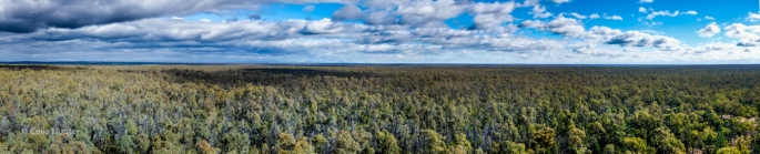
This is the Pilliga. Small huh! This image is 4 wide-angle shots stitched together to create an extra-wide 90Deg single pano. The Fujifilm X100T. Copyright Celia Hunter
The Pilliga is an iconic landscape of the Australian inland and is the largest forested woodland area in the state of New South Wales, west of the Great Dividing Range. These unique forests cover an area of 3,000kms² – serviced by 4,000kms of unsealed roads and management trails which were originally constructed over the past 70 years to daily serve the logging industry that once thrived here. Today though, it is more about Coal Seam Gas in the Pilliga, but more about that later.
By contrasts, the Pilliga quickly fluctuates between Cypress pine to Ironbark, to Scribbly Gum, to Box, and back again in just a few hundred meters. The Pilliga forests also consists of expansive heathlands, large red river gums that line the many sandy creeks and more than 300 species of birds, mammals, reptiles that make the Pilliga their home.
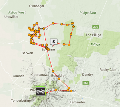
Our GPS coordinates of our journeys in and around the vast forest woodlands of the Pilliga, NSW.
The logging industry of yesteryear has long finished and only one of the dozens of timber mills that used to operate in this region remain open today. The rural township of Baradine – the gateway to the Pilliga – nowadays heavily relies on farming, but especially tourism.
When the logging industry in the area commenced winding down back in the early 2000’s, it quickly had a devastating effect on the prosperity of the town. Baradine’s progress committee heavily lobbied the then NSW Premier Bob Carr to have his government invest in the town to promote tourism and to especially promote the unique ecology of the Pilliga. Carr agreed and has since, sealed key roads into the town and subsequently, built the wonderful Pilliga Discovery Centre in the middle of the Baradine township. As a rule, we typically don’t like going to many tourist traps attractions on our travels however this centre, which also serves as the regional National Parks and Wildlife Service (NPWS), was a rewarding exception. The centre is fantastic and is a must-see if ever in town, with great historical displays of the former logging industry combined with fantastic exhibits of the vast flora and fauna of the Pilliga.
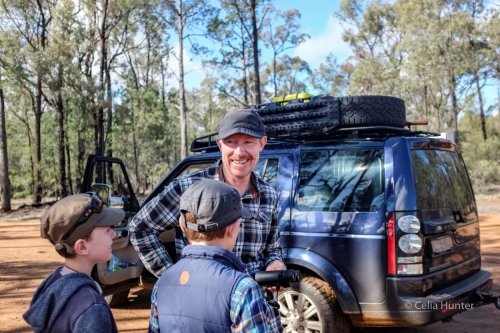
Geoff, sporting an unkept tashe, and the boys spotting numerous birds that live at the “salt caves” area of the Pilliga NP. Copyright Celia Hunter
The Pilliga offers scenery that is distinctly different and thus, making a visit to the Pilliga quite different as far as ‘typical’ Australian forests are known.
We spent 3 days amongst the many forest corridors of the Pilliga covering 315kms and when looking back on our GPS map co-ordinates, one could easily deduce we had taken a walk, not driven, and our various trips into and out of the national park barely scratched the surface of this vast area.

An example of a good Pilliga road. Hard-packed sand with little to no corrugations which we often found reasonably good in wet weather – although we did find the exceptions. Copyright Geoff Hunter
As large as the Pilliga is, there are limited options of how to get around and navigate. The vast majority of roads are from old logging tracks that are often suitable to 2WD *if* no rain has recently fallen. This was not the case for us, where 4WD was recommended by the NPWS office due to the large rainfall in the weeks leading up to our arrival. The NPWS also provide detailed maps of the park and one option they recommend is to follow the numerous “birding-routes” that are promoted by the discovery centre. A well-known local ornithologist, with support from the NPWS, have put together a set of comprehensive route maps divided into 8 different sections to allow ‘relatively’ straightforward navigation throughout the masses of mazed roads across the Pilliga and we ended up covering 3 of the 8 bird-routes over the 3 days.
We did end up using a combination of the provided birding-maps and our HEMA maps to navigate in the effort of not getting too lost. A few wrong turns here and there, trails simply vanishing and the like are all par for the course in exploring the Pilliga and just adds to the discovery of it all. Most bird routes travel through a combination of prime sheep and cattle grazing land, farming lands (mostly cereals we could see) and the dense forests – it’s quite a stunning contrast. Amongst it all are several wetlands that extend down to this part of the state with creeks and permanent man-made dams are also dotted throughout with a concentration of wildlife centred around and near these semi-permanent waterholes.
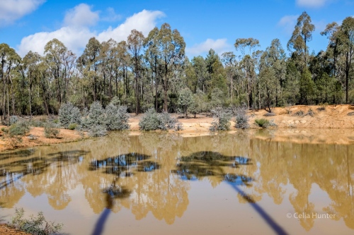
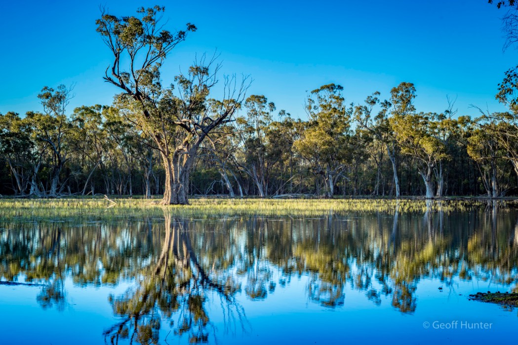
Where there is water, there are usually birds. We found no birds on or around this Pilliga dam but we did find these two lovely shadows. Copyright Celia Hunter
The Pilliga sandstone is the foundation of everything that is the Pilliga – and it’s everywhere. Most roads are made of rich red sand and red-clay base as are most walking trails we experienced which is why the area can be shut down after not too much rain. However we found most trails and paths to be not too bad considering the few inches of rain they had.
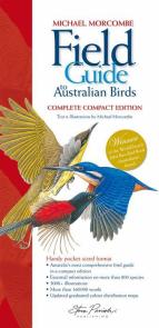
A great Aust. bird field guide.
Upon arriving at the Pilliga discovery centre on day 1, it was just after 9am, a grey overcast day, 7 degrees, and the place appeared deserted. We were the only ones at the centre and the park ranger on duty at the time gave us all the time we needed and offered lots of good information about where to go and the best way to get around to see the Pilliga.
And by a stroke of luck …the night before we almost bought online the Field Guide of Australian Birds by Michael Morcombe to compliment our existing Birds of Australia IOS app by Pizzy & Knight we have been using throughout our trip. The discovery centre had this guide (& many others) for sale at a reasonable cost and we couldn’t resist buying it. What a wonderful book, which just reinforces the fact how lucky Australia is to have such a diversity of birds in our magnificent forests.
Out into the Pilliga you can reach the first forest section in under 10 minutes from the centre of town. We decided to follow designated bird routes #8 & #7 which also take in the sandstone and salt caves where a new 4 story steel constructed observation tower has been recently erected after bushfires 3 years ago burt down the old structure. We took a packed lunch, 10 odd-litres of drinking water and a little over an hour later reached the Salt Caves having not seen another soul at any stage of the journey. The campground and picnic area here is modern and very well appointed with new free gas stainless steel automatic BBQ’s, plenty of fresh tank-water, good shelter for seating, and well-made hardwood picnic tables and seats and the new observation tower is 100M away. It was interesting to observe Aidan & Lochie in how they were effected by vertigo whilst on the tower’s top deck …they weren’t. We were hoping they both would have some affliction to heights – as opposed to none – as suffering from some degree of vertigo is always better when teaching someone to abseil (or outdoor rock climb) as we were going to do next week whilst at the Warrumbungle Ranges. To most people, having a little vertigo means taking less risk, as you have a “natural inclination” to life preservation. Still, this early observation may be very different when they soon back their posteriors out over a 10M+ cliff attached to a 10mm rope? 🙂
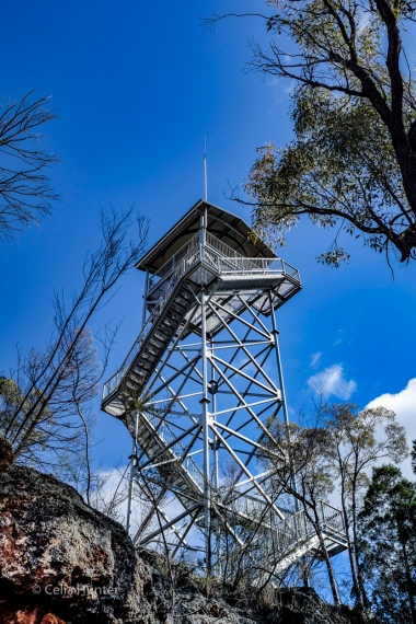
The new salt caves observation tower – Pilliga National Park Reserve. Copyright Celia Hunter
Standing in the car park at the salt caves, we could hear several bird species around the forest canopy, mainly Honeyeaters, Butcher birds, Treecreepers and Robins, but we had some difficulty in spotting any of them. After lunch, we all climbed up the new observation tower once again to which if you do, you will get a great impression of how vast and flat the Pilliga is with the panorama image above taken with Celia’s Fuji XT100 from the top deck. There was very little breeze lower down but it was still brisk and the skies were reasonably clear with a few scattered clouds rolling through the area. Afterwards, we walked the gentle 2 km single trail down to a neighbouring campground where a permanent man-made dam was, to see what wildlife we could find there. When we arrived, a pair of blue-billed ducks took flight and circled us and the dam for 5 minutes before building up the courage to land back on the dam again, once we hid behind some trees. I had never seen this type of duck before we visited Bowra the week before, and what a pretty little duck these are. They were too far away to take a decent photograph of, so all we could do was look at them from a distance in the 8 x 42 binoculars. Later that day, in section #7, we saw many feral goats and unexpectedly, a couple of striking looking wild horses. A couple of times we could also hear feral pigs but could not see them despite, sadly, evidence of their destructive presence in the forest almost everywhere.
Back at our camp in Baradine, we were chatting to the camp caretaker Charley. A lovely man who was looking after a couple of his nephews as it was nearing the end of school holidays. Whilst we were chatting, one of his nephews swung a golf club too close to another nephew and hit him in the mouth with the club head with a dull-thud and immediately bled – the sound it made was sickening. I quickly took a look and could not see where the blood was coming from and quickly found a broken tooth. Charley calmly took him to the local triage centre for an assessment and apart from a broken tooth and a couple of split gums, the young boy was fine the next day apart from evidence of a bruised lip. One tough “bush kid”.
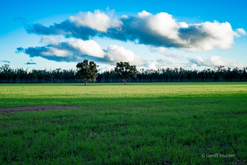
Where farmland meets dense forests. Many small cleared gazing corridors like this property above are scattered around the perimeter of the Pilliga. Copyright Geoff Hunter
The following day, the weather was a little overcast and we wanted to explore a little deeper into the forest – especially along some of the more remote management trails. A couple of hours in and most of these were one boggy section after another, readily going from high to low 4WD range with the winch control at the ready just in case. There was no such need in the end but we did cover some interesting ground and on one particular trail on bird-route #3, it came to an abrupt end as the road veered directly into what can only be a swamp marsh. Although the map showed a wetland, it was not too close to the road, or so we thought. We all got out to get a closer look at it and see where the road actually headed that was now completely underwater and to see if access, and more importantly, a safe exit was possible? We could see in the distance where the road exited the marsh approx 400M away but that was about it. Quickly though, we took the low risk decision and conducted a 7 point turn or so on the small trail to backtrack 8-9 kms to the start of the trail head and then headed for home soon after.
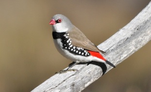
A Diamond Firetail Finch – Creative Commons
The following day, after a morning drive in sector #3 before lunch, Aidan I drove back to the location we were at yesterday where the road disappeared into the swamp. This time, we wanted to shoot a couple of photos of this lovely looking marshland and its resident inhabitants, and to once again assess if it was passable. When we had arrived, we were standing on the water’s edge looking at the various duck species when a small brown/grey bird flashed before our eyes and perched up high in a nearby Scribbly gum. He turned out to be the not so common (for these parts) highly colourful and distinctive Diamond Firetail Finch. He was far too high for us to photograph (only had a 90mm prime lens with us) but we did watch him for a minute or so through the binoculars before he flew off. What a nice find.
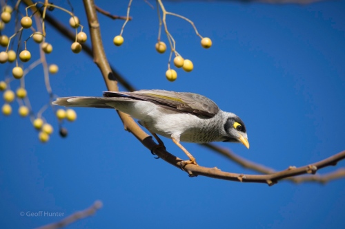
A popular native Miner in the Pilliga. Copyright Geoff Hunter
Not long after the Firetail sighting, a nearby Noisy Friarbird at the swamp’s edge started up singing their highly distinctive song repertoire, ever so proud and loud. His singing went on unabated for several minutes, all the while we were taking photos and swatting mosquitoes. Upon reflection, it was a moment I wish I could have voice recorded the conversation because it was just gold and went like this;
Aidan: “Oh boy dad, i’m sick of that noisy Friarbird singing like this non-stop and I wish it would just shut up, or fly away or something, and stop disturbing the peace. Doesn’t he know he will drive everyone mad with that noise, what’s up with him?”.
Dad: I laugh, stop what I was doing behind the tripod, turn to look at him to say; Yes, I say with a wry smile …”all too familiar isn’t it Aidan – this incessant never-ending noise by someone or something”.
Aidan:”Yes it is dad, unbelievable. A little bit of noise is fine, but it gets too much sometimes, even me for someone who doesn’t always listen, but I am now and I wish I couldn’t“.
…Oh, the irony I thought – not quite a 21st birthday embarrassment moment to put into the archive, but still lovely just the same 🙂
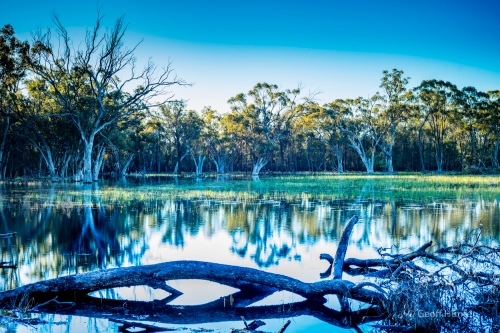
There are a number of swamp marshes in the Pilliga and this one was where the trail headed between the logs immediately in front and the green reeds further out. We decided to turn around and back track on this one. Copyright Geoff Hunter
Eventually, the Friarbird moves on and, after a few photos and waiting for the sun to set lower in the sky, we set upon taking a closer look at the swamp crossing. After several minutes of walking the banks I abandoned the idea altogether. The number of tree branches and other submerged tree debris along the submerged road was too much. You could see the pathway which was firm underfoot but there were too many fallen branches and other stuff to contend with. Just never know what you’ll hit so we quickly turned our attention back to the impending sunset.
Back behind the tripod, a couple of decent clouds were lining up in a nice position central to the large tree in the middle of the swamp, but it was still too early for a good photo as the light was too harsh. Waiting for the light to change we stood watching a few Grebes scuffling with each other in one area and Pink-Eared ducks were carefully watching us from a distance – all of which were about 100M away. There were strong winds up high and the nice looking clouds of 15/20 minutes ago had now rolled out of the scene by the time the light toned down – unfortunately, now with a featureless sky above the swamp.
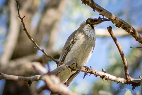
A Noisy Friarbird living up to its name. Copyright Geoff Hunter
I quickly come to the realisation it was not going to improve so we turned over a few shots anyway as the marshland and surrounding trees of the swamp was looking lovely and now quite still, despite the ever-presence of annoying mosquitoes. Meanwhile, a busy flock of Zebra finches fly in nearby seeking their last meal before nightfall and it was lovely and enjoyable to be out amongst it. Aidan also had a good time by this stage trying to catch frogs since the Noisy Friarbird left the area and he could hone in on the frogs calls. Not long after we were back in the car and heading home negotiating a few muddy bogs along the way. It was well after 5pm by this stage and Kangaroos and Wallabies were now scattered along the trails and roads which made our 45 minute journey back to the campground take twice as long – but we didn’t care.
Over the course of three days we added 7 new bird species to our trip sightings list with 76 different species counted altogether in the Pilliga bird-routes as was submitted to the NPWS in Baradine.
The Pilliga and CSG
The Pilliga is a dry arid place with little natural ground-bearing water and proven to be susceptible to long periods of difficult drought. The forest is very large and important for wildlife and farmers largely depend on the great artesian that sits beneath. However the Pilliga is slowly changing – not from constant bushfires or occasional logging, but worse than this, from coal seam gas exploration. Yes, across the national park.
Coal seam gas (CSG) organisations have been active and various wells are already setup and causing major salinity and contamination problems for farmers, graziers, ecologists and Aboriginal people. Artesian waters, in some cases in and around the Pilliga, are already being contaminated from the fracking process with plans for hundreds of more wells in the coming few years. I have never been a greeny as such, however fracking for coal seam gas, another fossil fuel, especially from such fertile and useable land, is nothing short of absurd. The Pilliga averages less than 450mm of rainfall per year which is not a lot and so many farmers and graziers depend on safely tapping the great artesian bore that sits below the Pilliga. I just don’t understand why governments allow this abhorrent practise to continue when the knock-on effects are so well documented, if perhaps poorly understood. Check here for a pictorial of the effects of CSG in the Pilliga today.

Wilderness.org
But whatever the real reasons are for the government to allow this practise to continue, the Pilliga is the largest remaining unfragmented block of temperate dry forest in eastern Australia. It also functions as a key refuge for hundreds of native plants and animals in a landscape largely cleared for agriculture. It is part of an Australian National Biodiversity hotspot and is home to rare species and is recognised as a globally significant Important bird area. The Pilliga is an important, biodiverse ecosystem. It is also a significant recharge area for the Great Artesian Basin, one of the largest underground water reservoirs in the world and the most important ground water resource in arid and semi-arid eastern Australia …yet, we’re allowing CSG all over it. Lunacy!
We don’t necessarily wish to end a post on such a beautiful area in such a negative tone, however CSG is a huge growing concern and the more CSG is understood and debated in general terms, perhaps the collective view can bring about a positive influence in its change and hopefully, assist driving a ban on its practises in such beautiful forests as the Pilliga.
Geoff & Celia

How are you guys ever going to settle back to norbillty.? We are back at Mission Beach our home is rented until
The end of January now. We dont now how we we we will cope with looking after a home and 1/3 of an acre again and the cleaning of a house after the van.How is your job prospects looking Geof?.Arewe to have you as neighbours. Love your blog and the photo’s are amazing love to you both and Locky and Aiden xxKerrie and David
LikeLike
Can’t eat coal, can’t drink gas. Governments don’t seem to care and certainly don’t seem to monitor this exploitation of Australias natural, finite and precious assets.
LikeLiked by 1 person
Exactly Kim …begs the question; Are we ever likely to move completely away from relying on fossil fuels …not likely for decades, possibly not even in my lifetime which is extremely sad.
LikeLike
Great post! Lovely to see you and the boys in a shot 🙂
LikeLike
Thanks Mel. 🙂
LikeLike
Hello Geoff
Can you give me the location and names of the swamps within the Pilliga?
Thanks
Daniel
LikeLike
Hi Daniel,
Thanks for your query – I will respond in more detail to your received email.
Geoff
LikeLike